


Winter 2025–2026 Outlook
A Transitional Pattern With Northern Chill and Southern Warmth
ENSO Forecast: From Weak La Niña Toward Neutral
ENSO predictions from the Columbia Climate School’s International Research Institute for Climate and Society (IRI) continue to show a gradual shift from weak La Niña conditions this fall toward neutral or slightly warm values through the winter months. Probabilities favor a neutral ENSO developing by early spring 2026, with Niño 3.4 sea surface temperature anomalies rising from roughly –0.7°C in October to near or slightly above 0°C by late winter.
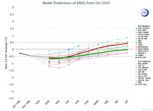
This kind of transition often brings greater variability across North America, producing alternating warm and cold periods rather than one dominant pattern. In our analysis, this evolving ENSO background serves as the foundation for identifying which past seasons most closely align with current oceanic and atmospheric conditions—those “analog years” that help shape our expectations for the upcoming winter.
Analog Years: Building on Past Patterns
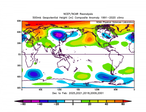
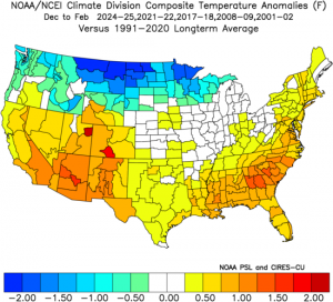
When we compared the current ENSO behavior, sea-surface temperature anomalies, and upper-level circulation signals, five past winters stood out as the closest matches: 2024–25, 2017–18, 2021–22, 2000–01, and 2008–09.
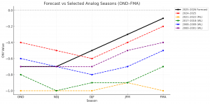
Each of these seasons began with weak La Niña characteristics before moving toward neutral, and each produced varying degrees of a ridge near the Gulf of Alaska paired with a trough over Hudson Bay extending into the Great Lakes. Our analysis of these analogs suggests that the upcoming winter may follow a similar pattern—coldest across the northern tier, with milder and less active conditions farther south and west. The highest-ranking analogs, particularly 2024–25 and 2017–18, featured recurring cold intrusions across the Upper Midwest and Great Lakes with periods of moderation in between, while 2000–01 and 2008–09 offered similar late-season cold patterns but slightly weaker early-winter signals.
Overall Pattern: Ridges, Troughs, and Model Agreement
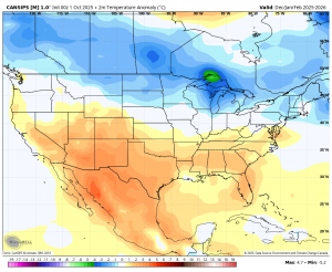
Beyond the ENSO signal, general model guidance—including output from CanSIPS, ECMWF, and other ensemble models—shows a consistent pattern. The models highlight a ridge near the Gulf of Alaska, a broad trough centered around Hudson Bay, and a secondary ridge over the North Atlantic. That Atlantic feature may not be a dominant block, but it could still result in a blocking pattern and help reinforce cold air in the eastern United States from time to time.
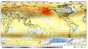
Together, these features favor a storm track that either begins in the Northwest or Central Plains, then runs through the Great Lakes and into the interior Northeast, while keeping much of the southern tier generally milder and drier. This setup aligns with what we typically see during a weak La Niña transitioning toward neutral, where alternating ridges and troughs produce a balance of cold northern flow and milder southern influence.
Temperature Outlook: Cold North, Mild South
General model guidance for December through February points to a clear north–south temperature split across the U.S.
The coldest conditions are expected over the Northern Plains, Upper Midwest, and Great Lakes, with temperature anomalies several degrees below normal. Pockets of deeper cold could also extend into the Northern Appalachians and interior Northeast. Meanwhile, the warmest areas will stretch from the Southwest through Texas and across the Southeast, where persistent ridging and a weaker polar jet should limit Arctic influence. The Pacific Northwest trends near to slightly below normal, depending on storm frequency.
Our analog comparison supports the same structure—persistent chill across the northern half of the country, mild air dominating the southern tier, and a volatile transition zone in between where conditions swing rapidly from week to week.
Snowfall Outlook: National Trends and Extremes
Our analysis of snowfall projections for Winter 2025–2026, supported by both historical analogs and current model guidance, shows significant regional contrasts across the continental United States.
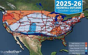
At the national level, snowfall departures highlight several distinct zones of overperformance and underperformance. The Pacific Northwest into the Northern Rockies stands out as one of the more favorable snow regions this season, with notable gains expected in cities such as Portland, Boise, and Great Falls. This region benefits from an active Pacific storm track and consistent cold air aloft. Similarly, the Southern Appalachians into the Tennessee Valley are expected to see an increase in snowfall, including around Nashville, Atlanta, and higher elevations nearby, as a more active southern jet stream occasionally interacts with intruding cold air.
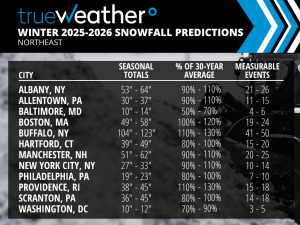
The northern tier of the United States, stretching from the Northern Rockies through the Upper Midwest and Great Lakes into the Northeast, also appears poised for a solid winter. Locations including Minneapolis, Fargo, Detroit, Grand Rapids, and Buffalo are all forecast to experience above-normal snowfall, while Boston and Providence could also trend higher, signaling potential for coastal storms when storm tracks align.
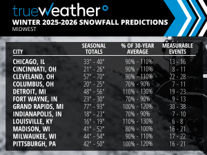
On the flip side, several regions are expected to struggle to reach average snowfall. The most consistently below-normal signals show up across Delmarva northward through the Susquehanna River Valley, central Indiana, the Southern Plains, and the Southern Rockies. Cities such as Baltimore, Washington D.C., Indianapolis, Denver, and Dallas are forecast to end the season with less snow than usual. This may be the result of systems frequently passing to the north, and when the trough of cold air does dig in, it may extend too far south for these cities to benefit.
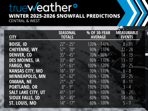
Between these extremes lies a broad zone of near-normal snowfall, including much of the Ohio Valley, Central Plains, and interior Mid-Atlantic, where seasonal totals will depend heavily on storm frequency and track. A few well-timed systems could easily push some of these areas slightly above or below normal by season’s end.
Overall, this year’s snowfall distribution reflects the influence of a transitional ENSO, where alternating ridges and troughs produce sharp regional contrasts rather than a uniform national pattern. The most favorable areas for frequent snow events include the Pacific Northwest, Northern Rockies, Great Lakes, interior Northeast, and Southern Appalachians, while the Southern Plains, Central Rockies, and Coastal Mid-Atlantic are likely to experience quieter winters and may just miss those more significant events.
When compared to our ranked analog seasons—2024–25, 2017–18, 2021–22, 2000–01, and 2008–09—this winter shares many similarities, particularly with the top-ranked years. Each featured active northern storm tracks, enhanced lake-effect snow, and late-season cold intrusions that helped the northern half of the country finish strong.
Summary
The Winter 2025–2026 season is shaping up as a transitional pattern—one that begins under a fading La Niña and evolves toward a neutral ENSO base. The most likely outcome features a ridge near Alaska, a trough over Hudson Bay and the Great Lakes, and intermittent North Atlantic ridging that may help reinforce cold across the northern United States.
Temperatures should average below normal across the northern tier, above normal in the South, and highly variable in between. From a snowfall standpoint, the greatest potential lies in the Northern Plains, Great Lakes, and interior Northeast, while the Delmarva region, Southern Plains, and Coastal Mid-Atlantic are likely to see fewer significant events and may just miss those more impactful systems.
When viewed through the lens of our ranked analogs, 2024–25 stands out as the most comparable season, followed by 2017–18, 2021–22, 2000–01, and 2008–09—each reinforcing the idea of a variable, northern-weighted winter with cold surges, regional snow extremes, and a late-season finish that keeps the northern U.S. firmly in the win column.