


Winter 2018-2019 Highlights
- Weather models project a weak to moderate El
- A weak to moderate El Nino favors snowier winters in the Southern US and along the Eastern US.
- Current top analogs for an El Nino winter are 1963-64 and 2002-03. The winter of 1994-95 analog has been replaced with 2006-07.
- The winters of 1963-64 and 2002-03 were cold and snowy for most in the Eastern and Southern US. The winter of 2006-07 was warm in the East with a late start to the snow season for most.
El Nino
- Current projections show a moderate El Nino for the Winter of 2018-19.
- Current values are already up to +0.9-1.0C in the western and central basins, suggesting the El Nino phase is developing as expected
Sea Surface Temperature Anomalies
- Over the last several months the warming in the Gulf of Alaska has expanded and intensified. Builds support for colder weather in Eastern US.
- El Nino continues to develop.
Top Analogs
- We are favoring 2002-2003 with the similarities to current pattern and the Sea Surface Temperature Anomalies (SSTA).
- The 1963-64 analog had an opposite SSTA configuration resulting in a slight downgrade on our analog chart. The low solar, QBO, and El Nino similarities still make it one of our higher weighted analogs.
- The 2006-07 analog is a “what could go wrong” analog. The strong Pacific Jet this winter caused a delay in snow for most of the Eastern and Central US until February. Current pattern does not favor a strong Pacific Jet, resulting in 2002-2003 remaining favored.
Pacific Decadal Oscillation
- Warm phase favors a ridge along the Western US and trough (colder conditions) across the Central and Eastern US.
- Cold phase favors a trough over the Western US and ridging (warmer conditions) across Central and Eastern US.
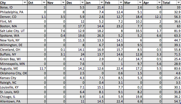
1963-64 Snowfall in Inches by Month
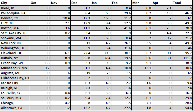
2002-03 Snowfall in Inches by Month
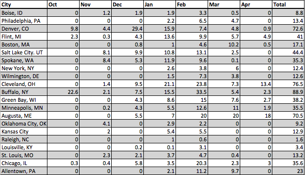
2006-07 Snowfall in Inches by Month
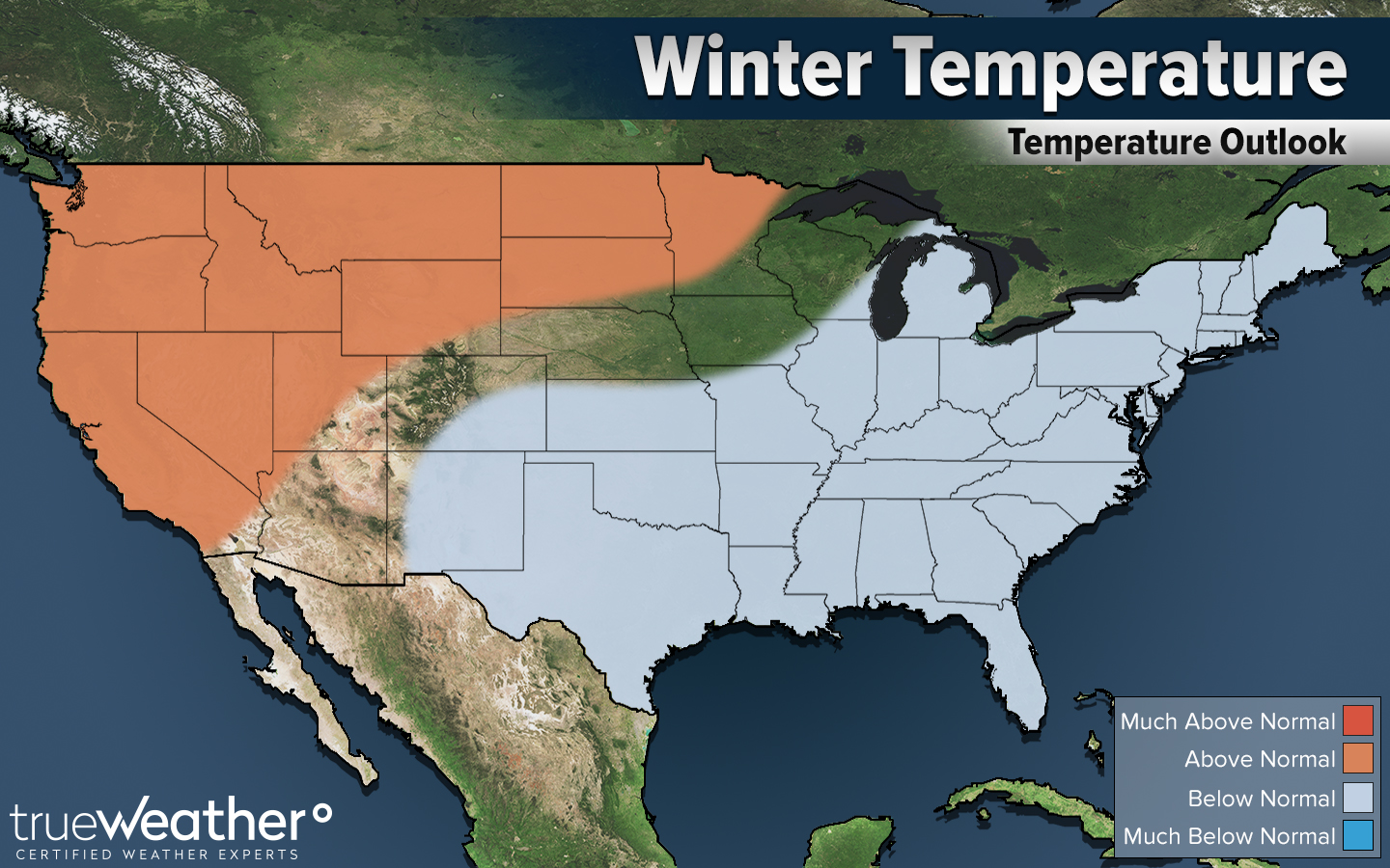
Winter Temperature Projection
Winter Snowfall Projection
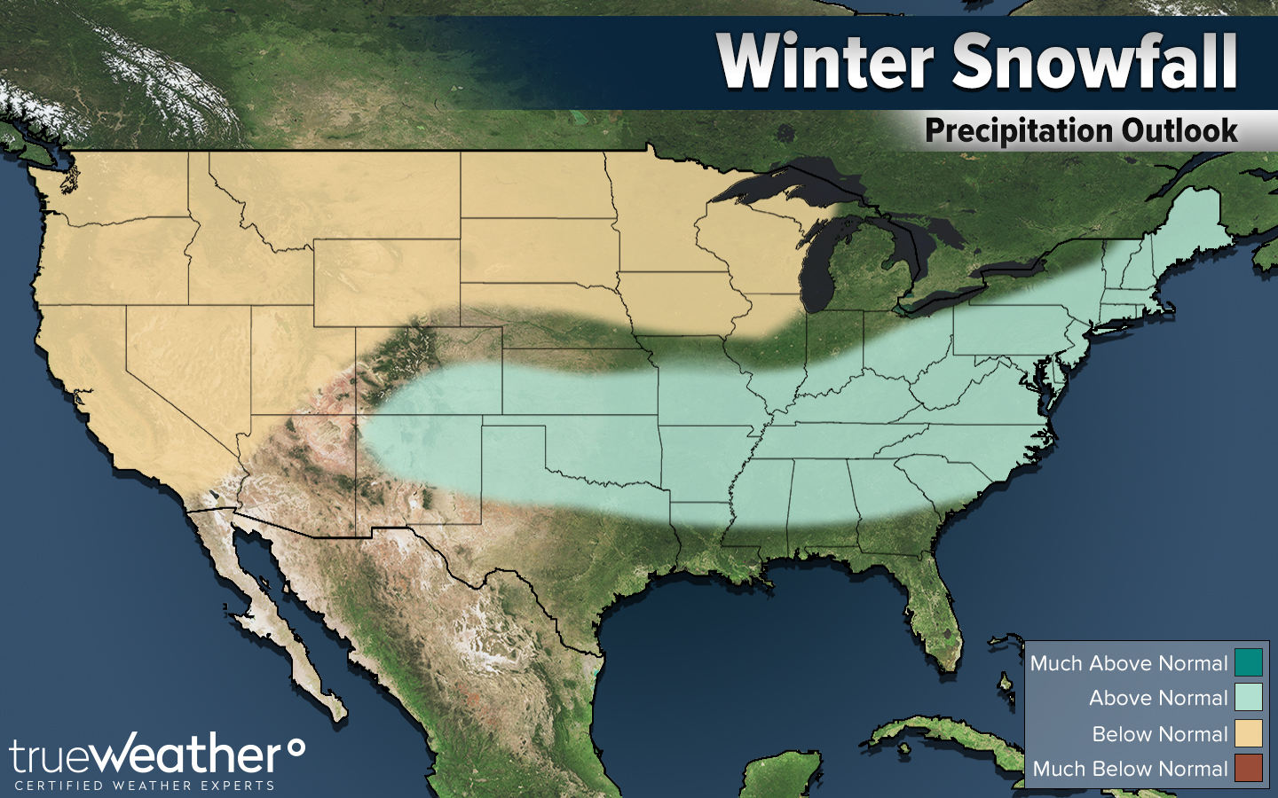
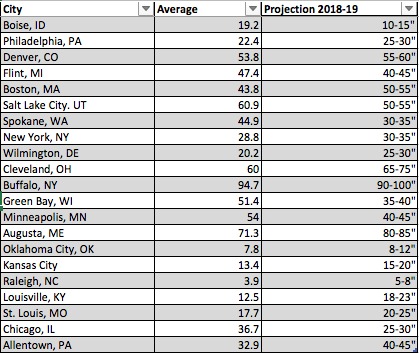
Current Snowfall Projection for 2018-19
Changes from previous update
- We increased the Lake Effect Snow areas to better align with colder intrusions moving over the Lake. By introducing the 2006-07 and 2002-03 analogs this greatly favors the Lake Effect Snow regions compared to most El Ninos.
- Current signals suggest an amplified pattern will persist across the Pacific resulting in many in the Eastern US getting an early shot at snow in December. If the Pacific Jet shows signs of strengthening this will have to be amended in the next outlook.
- February is being signaled as the greatest chance for below normal temperatures and above average snow for many in the Central and Eastern US.