


March 13, 2019 is a day that will go down in Colorado history for one of the most intense extratropical lows on record in the region, bringing record low surface pressures and record wind speeds in several locations as a result of the exceedingly rare intensity of this storm.
Figure 1. Upper-air pattern (500 mb heights) at 7am EST on Monday, March 11, 2019.On March 9, an upper trough over the Pacific Northwest began moving south along the west coast. Separated from the northern jet stream, this low became a cutoff low off the southern California coast by the morning of March 11 (See Figure 1) as energy embedded within the northern jet continued east to the Great Lakes and East Coast. Southwesterly upper flow resulted across the Southwest and Southern Plains, beginning to bring Pacific and Gulf of California moisture into Colorado.
Upper-air pattern (500 mb heights) at 7am EST on Tuesday, March 12, 2019
The upper low rotated into northern Baja California by the morning of March 12 (see Figure 2), and then began to track east and then northeast in response to the next upper trough moving into the Pacific Northwest. By the morning of March 13 (see Figure 3), the upper low was merging with the upper trough in the northern flow and intensifying rapidly in southeast Colorado and northeast New Mexico as it began lifting northeast into the Plains.
Upper-air pattern (500 mb heights) at 7am EST on Wednesday, March 13, 2019
At low levels, by 6:00am MDT on the morning of March 13, which is approximately the same time as the upper-level chart in Figure 3, moist flow had set up across the area from the Gulf of Mexico (see Figure 4; the green contours show dewpoints at and above -4° C at the 700 mb level). Between the low level moisture flow from the Gulf of Mexico and upper level southwest flow set up earlier from the Pacific Ocean and Gulf of California, plenty of moisture existed in the area. In fact, the significant snow event began on March 12 or even March 11 in most mountain locations.
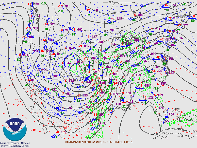
700 mb heights, winds, temperatures and moisture at 6am MDT on Wednesday, March 13, 2019, approximately the same time as Figure 3.
As upper-level lows begin moving into the Plains, lee cyclogenesis often occurs, which is the formation of a surface low, or cyclone, in the lee of the Rocky Mountains. This occurs primarily due to the conservation of angular momentum as the bottom part of the circulation over the mountains quickly stretches down to the lower elevations, causing a quicker and smaller rotation of the surface low. This means the low intensifies in the lee of the Rockies. There was also a strong temperature gradient across mostly southern Colorado, with cold air moving south on the west side of the upper low and warm air moving north to the east, and this temperature contrast also helped to intensity the surface low. Finally, the upper trough moving into the Pacific Northwest helped to bring colder air and additional energy into the Mountain West, further intensifying the upper and surface lows by the morning of March 13 and allowing it to rapidly intensify into the strongest surface low ever recorded in the state of Colorado.
The air pressure of 970.4 mb recorded at 11:16am MDT in Lamar, Colorado set a preliminary and unofficial record for the lowest surface pressure ever recorded in the state of Colorado (outside a tornado); the previous record was 973.4 mb in 1973. Stanton, Kansas recorded a lowest pressure of 971.9 mb (the Kansas state record is 971.6 mb). The low was officially categorized as a “bomb” cyclone, which means the low pressure in the center of the storm fell at least 24 mb in a 24-hour period. In fact, the minimum central pressure fell from 994 mb to 968 mb – a 26 mb drop – in only 16 hours from late on March 12 through March 13.
The exceedingly low pressure of this low led to a very large pressure gradient across the region, leading to damaging wind gusts at hurricane force from Colorado to southwest Texas and north to Wyoming and Nebraska. Colorado Springs recorded a wind gust of 96 mph, its highest ever recorded, while Denver recorded a wind gust of 80 mph, breaking their record for the highest non-thunderstorm wind gust by 17 mph. Denver also set a record low pressure of 979.0 mb. Wind gusts over 60 mph were widespread across eastern and southern Colorado. Hemingford, Nebraska recorded a wind gust of 89 mph, and wind gusts in Wyoming reached as high as 76 mph. Southern New Mexico and southwest Texas recorded wind gusts up to 104 mph.
In addition to the wind element of this cyclone, widespread blizzard conditions were observed across Colorado as rain changed to snow in the cold air diving south to the north and west of the low. Blizzard conditions also occurred as far north as South Dakota as the low moved northeast into the Plains. Up to 6-10 inches of snow fell in the Denver area, with over a foot of snow in places along the Palmer Divide between Denver and Colorado Springs. Wolf Creek Pass in southern Colorado, west of Alamosa, received 52 inches of snow from this event. The most intense blizzard conditions were reported across El Paso County in east central Colorado, where I-25 closed for over 24 hours from March 13-14 and around 1500 motorists were stranded north of Colorado Springs due to the extreme blizzard conditions. Figure 5 shows observed snowfall and maximum wind gusts across Colorado from March 12-14.
Snowfall and maximum wind gusts recorded across Colorado for the March 12-14, 2019 period. Maximum wind gusts are labeled in bold black and are selected reports over 60 mph (and up to 96 mph) from reports gathered from the National Weather Service and local television network websites across Colorado.This “bomb cyclone” on March 13, 2019 will be written in weather history as one of the most significant extratropical low pressure systems ever observed in the Central Plains and east of Colorado’s Front Range. It developed as typical lee cyclogenesis often does, but its intensity benefited greatly from a large temperature gradient in Colorado and added cold air and energy from the Pacific Northwest, leading to record low pressure and wind gusts across eastern Colorado and adjoining areas, a region that rarely sees extratropical cyclones intensity nearly as quickly as this one. Not until these ingredients combine in such an ideal way again will we likely see another storm quite like it.
By: Nicholas Eckstein
trueWeather Meteorologist
trueWeather provides 24/7 year-round forecasting, alerting, certification and reporting services for contractors, public works departments, school districts, entertainment venues and more.
trueWeather has a feature-rich weather dashboard tailored to your specific needs – including mobile apps and instant access to our team of meteorologists and much more. Clients trust trueWeather to provide an unbiased view into how weather will directly impact their operations – starting at just $350/annually. Give us a call at (844) 614-1298 to receive a no-hassle instant quote, or email us at directsales@truewx.com.