


WINTER 2025-2026 OUTLOOK
The upcoming winter season will be shaped by a mix of familiar patterns from past years and unique factors that could steer it in a different direction. While some signals point toward a winter reminiscent of 2013–14, marked by prolonged cold in the East, other indicators raise the possibility of a milder outcome similar to 2001–02.
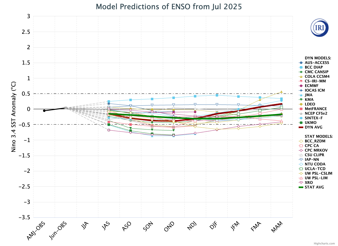
Images and Data provided by The International Research Institute for Climate and Society, Columbia University Climate School. The graph shows forecasts made by dynamical and statistical models for SST in the Niño 3.4 region for nine overlapping 3-month periods.
Key Climate Drivers
This winter is expected to begin in a neutral ENSO phase, but near the threshold of a weak La Niña, a setup that often strengthens the Pacific jet stream and influences storm tracks across North America. Model guidance suggests the ENSO state will trend further toward neutral as the season progresses, which could shift jet stream patterns and alter the distribution of cold air during the second half of winter.
Another major player is the unusually warm sea surface temperatures in the Pacific, particularly in the Gulf of Alaska region. Forecast models indicate a prominent ridge may set up here, a feature historically linked to colder eastern U.S. winters, provided it works in tandem with favorable blocking patterns. Warm Pacific waters can also energize the jet stream, which, if too strong, could keep Arctic air bottled up in Canada.
Historical Analogs and Seasonal Possibilities
When comparing this year’s setup to past winters, 2013–14 stands out for its strong Pacific ridge, favorable blocking, and repeated cold outbreaks in the East. If similar conditions develop this year, the result could be a more winterlike pattern with frequent cold shots and increased snow opportunities for much of the eastern United States. On the other hand, the pattern could take on characteristics of 2001–02, when a dominant Pacific jet and limited blocking kept Arctic air confined to Canada, producing a milder and less snowy season across much of the country. A third analog, 1996–97, shares some similarities but differs in key atmospheric structures, making it less representative of the current setup.
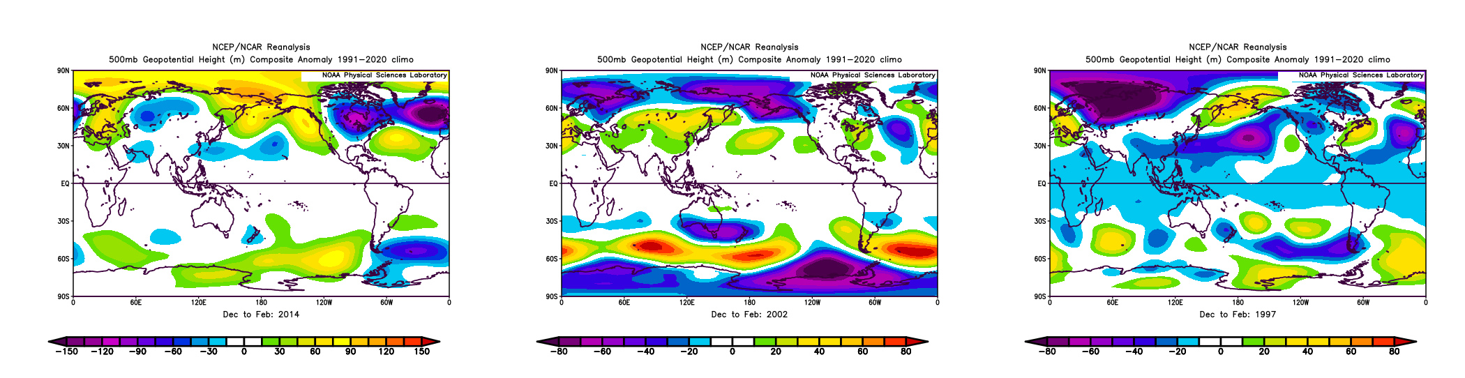
National Oceanic and Atmospheric Administration, Physical Sciences Laboratory. “Monthly/Seasonal Climate Composites.” NOAA Physical Sciences Laboratory
The deciding factors will likely be the strength and persistence of the Gulf of Alaska ridge, the behavior of the polar vortex, and how quickly the borderline weak La Niña signal fully fades into neutral. If blocking patterns emerge during the mid to late winter period, especially as the ENSO state trends neutral, colder conditions in the East become more probable. If not, a warmer outcome becomes increasingly likely.
Regional Trends in Similar ENSO Seasons
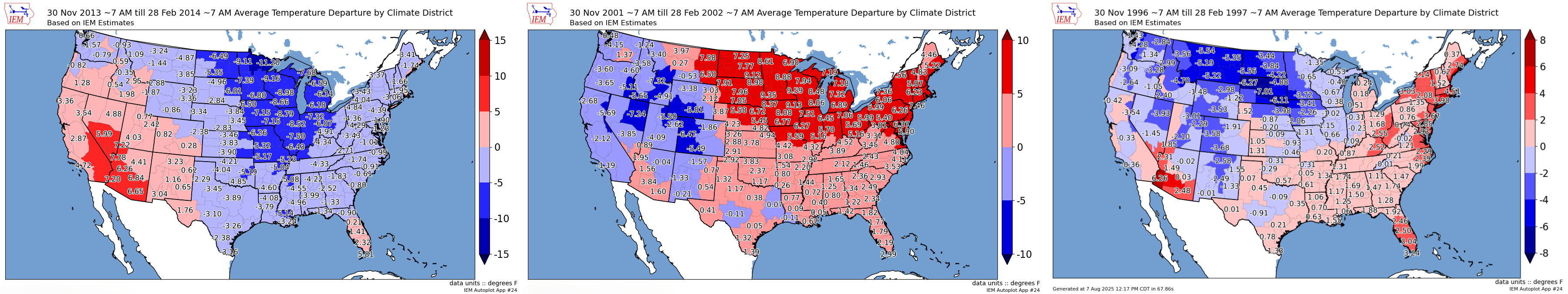
Iowa State University, Department of Agronomy. “Automated Data Plotter.” Iowa Environmental Mesonet, Iowa State University of Science and Technology
Historical data from past borderline weak La Niña to neutral winters provides some insight into possible regional outcomes. The Pacific Northwest often trends wetter than average with near to slightly above normal temperatures, while the Northern Plains can experience large swings between sharp cold outbreaks and milder spells depending on the jet stream’s position. The Southwest tends to be drier and warmer, though occasional systems can bring meaningful precipitation to the southern Rockies. Across the Midwest and Great Lakes, snowfall potential often increases when blocking patterns set up, while the Northeast can see prolonged cold and snowier conditions if the Gulf of Alaska ridge remains strong. In contrast, the Southeast typically experiences a warmer-than-average winter with limited cold air intrusions, though short-lived cold snaps are still possible.
Outlook Summary
The 2025–26 winter will begin in a neutral ENSO state close to the weak La Niña threshold, which could initially support a more active Pacific storm track. As the season settles into neutral conditions, the pattern could shift, opening the door for more blocking and cold outbreaks later on if the right atmospheric alignments occur. While the setup bears resemblance to the cold and active winter of 2013–14, the potential remains for a milder outcome similar to 2001–02 if blocking fails to develop. The next several months of atmospheric trends will be critical in determining which path this winter ultimately takes.