


As we look ahead to the winter of 2024-2025, one of the most significant factors influencing our outlook is the anticipated state of the ENSO (El Niño-Southern Oscillation) during the colder months.
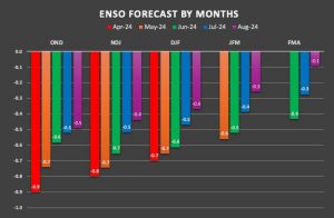 Earlier in the year, initial forecasts suggested a winter leaning towards a weak to moderate La Niña. However, recent trends indicate a shift toward a more neutral ENSO state for the upcoming winter.
That said, the October-November-December (OND) timeframe is expected to start near the threshold of a very weak La Niña, with temperatures hovering around -0.5°C. This phase is likely to persist through the end of 2024, possibly extending into early 2025, before transitioning toward a true neutral state around 0°C.
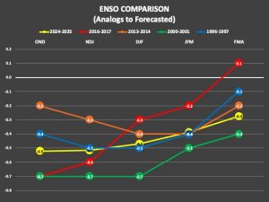 While ENSO predictions are a key component of any winter outlook, they should not be viewed in isolation. However, they are particularly useful when identifying potential analogous seasons. Notably, the winters of 1996-1997, 2000-2001, 2013-2014, and 2016-2017 share similarities with the current ENSO forecasts, both in terms of strength and trends, which could provide insights into the upcoming 2024-2025 winter.
Comparing these four winters, it’s evident that the winters of 2000-2001 and 2013-2014 were generally colder, while 1996-1997 and 2016-2017 were milder. One notable difference lies in the Gulf of Alaska, where lower heights, or a trough, dominated and brought Pacific air into the contiguous United States (CONUS) during the winters of 1996-1997 and 2016-2017. In contrast, a ridge over this area in 2000-2001 and 2013-2014 contributed to a colder air mass across much of the CONUS.
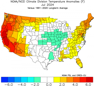
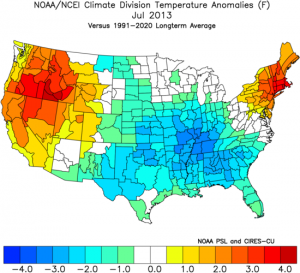
Sea Surface Temperature (SST)anomalies give a slight edge to the 1996-1997 winter, but the 2013-2014 winter is particularly intriguing due to its strong alignment with current temperature trends across the CONUS for July and August. The recent temperature profile across the country, with extremes in both the Northwest and Northeast, resembles conditions experienced in the summer of 2013.
Based on this information, trueWeather is currently leaning toward the winters of 2013-2014 and 1996-1997 as the most analogous seasons, with 2013-2014 being the leading candidate.
So, what does a neutral ENSO winter mean for snowfall across the contiguous United States?
During neutral ENSO winters, where neither El Niño nor La Niña conditions are dominant, snowfall patterns across the CONUS can be highly variable.
However, several general trends are typically observed:
- Overall Variability: Neutral ENSO winters often exhibit greater variability in snowfall amounts and frequency, compared to winters influenced by El Niño or La Niña. Some regions may experience above-average snowfall, while others may see below-average totals, with no consistent pattern across the entire CONUS.
- Northern Tier States: The northern states, including the Great Lakes, Upper Midwest, and Northeast, tend to experience near-normal to slightly above-normal snowfall. The lack of strong ENSO signals allows for more frequent cold air outbreaks from Canada, which can enhance snowfall, particularly in lake-effect snow regions.
- Southern and Central Plains: These regions typically see near-normal snowfall. However, the variability of neutral winters can lead to anomalous events, such as significant snowstorms or extended periods of mild conditions.
- Northeast and Mid-Atlantic: Snowfall in the Northeast and Mid-Atlantic is highly variable during neutral winters, with a mix of coastal storms (Nor’easters) and inland snow events. The frequency and intensity of storms can vary widely, leading to winters with either above or below-average snowfall.
- Western U.S.: The Pacific Northwest often experiences near-normal snowfall during neutral winters, as it is less influenced by the absence of a strong ENSO signal. The Sierra Nevada and Rockies may see slightly above or below-average snowfall, depending on the specific atmospheric patterns that develop.
- Southeast U.S.: Snowfall in the Southeast is typically low, regardless of the ENSO phase. However, neutral winters can occasionally bring snow or ice events, though these are usually isolated and driven by specific weather patterns.
- Alaska: While not part of the CONUS, Alaska often experiences colder-than-average conditions during neutral ENSO winters, which can lead to increased snowfall in certain regions.
In summary, neutral ENSO winters do not exert a strong, predictable influence on snowfall patterns across the CONUS. Instead, local and regional weather patterns, influenced by factors such as the Arctic Oscillation (AO) and North Atlantic Oscillation (NAO), play a more significant role in determining snowfall outcomes.
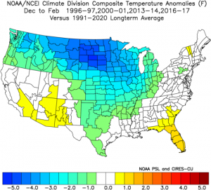
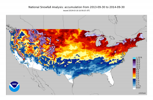
Given this context, trueWeather preferred the analog winter of 2013-2014 over 1996-1997 because it exhibits strong signals of near to slightly above-normal snowfall for much of the Northern Tier, accompanied by consistent cold air outbreaks.